The creation of a “neutral zone” in the Aegean, the loss of the Southern Mediterranean and the national mutilation
iEpikaira.- (published 12:26-29/03/2024, updated 13:30-08/04/2024) This article presents evidence that sheds light on the background of a looming plan to redraw the maritime borders between Greece, Turkey and Cyprus. The Aegean and the Eastern Mediterranean are examined separately, but it turns out that they constitute parts of the “Grand Strategy of the United States”, which is being implemented step by step.
The Aegean archipelago
Starting from the Aegean, “erasing” instead of “redrawing” the existing borders is a more accurate description of what is planned, creating a corridor that will be considered as an “International Strait” and not as “Open Sea”.
Professor Ioannis Mazis, in June 1997, argued that “the Aegean will not belong as Area of Responsibility to Greece, instead Greece will be responsible [only] for the defense of greek islands and the territorial waters”. He added, “it is obvious that the concept of the Area of Responsibility in the form of command and control ... is significantly degraded with the new architecture of the NATO Alliance. In maritime operations, the so-called Task Force Concept will be applied, according to which NATO forces will act dominantly in the central Aegean, over which they will also have operational control. Regarding air defense and information exchange (Cross Tel) it is almost certain that the Turks will try to push the geographical border of Information Exchange to the middle of the Aegean archipelago! This would likely mean -if accepted- the loss of the Aegean.”
The well-informed journalist Manolis Kottakis wrote in “ESTIA” newspaper back in August 2020 (republished in March 2022):
“My reliable source from the other side of the Atlantic at an unsuspected time -the EEZ segmental delimitation agreement between Greece and Egypt had not even been signed back then- informed me, as per a confidential conversation with a high-ranking member of the US Congress. My reliable source reported that the Congressman conveyed an assessment according to which a Peace Agreement between Greece and Turkey is being conceived by which Greece will be invited:
1. To expressly give up -throught an international treaty- its right to extend its territorial waters to 12 miles in the Aegean. The declaration of Madrid, which led to the suspension of the exercise of the Greek sovereign right for 23 years, is no longer enough. Its formalization is requested. The US argued that even if Greece extended to 12 nautical miles of territorial waters, it does not have sufficient forces to carry out surveillance on warships or on commercial ships. So it should settle with “selective expansion” of territorial waters as former PM Kostas Simitis suggested (in some places 10 n.m., in others 8 n.m. and some will remain at 6 n.m.).
2. A bilateral agreement or arbitration will call for withdrawal of greek troops from the Aegean greek islands with the simultaneous retreat of the Fourth Army of Smyrna to the turkish hinterland.
The goal of such an agreement would be -according to the Congressman-, to create a “neutral zone” west of 28 supposedly demilitarized greek islands. A “neutral zone” to serve international navigation between Suez and the Dardanelles.”
Pressure for 12 nautical miles territorial waters
The well known defence and security greek website militaire.gr wrote on 03/21/22: “The Congressman’s cynical confession is partially confirmed by Admiral Christos Lymberis -then Chief of the Hellenic National Defence General Staff-, who has publicly stated that: “What I experienced in November 1994 [when the international convention on the Law of the Sea came into force which allows the extension of the territorial sea to 12 n.m.] as well as in January 1996 [during Imia crisis] was the burdensome pressure on the part of the US to NOT exercise the right to extend the territorial waters. Thus, Athens renounced the use of a strategic weapon, both in the active phase of the crisis during the mediation and in the political dialogue that followed the de-escalation”. The Admiral, in his briefing to the Greek Ministry of Foreign Affairs, even stated that: “The Americans argue that the extension of our territorial waters will negatively affect American naval operations, because Greece refuses to accept that all of the straits are governed by the right of free transit passage. What will this mean for Americans? Firstly, US submarines will surface in straits that are not designated as international. Secondly, American aircraft will be prohibited from overflying these straits and thus will be forced to seek the consent of Athens… I have been informed of US instructions to their submarines, according to which five specific straits in the Aegean are considered as ‘straits of free passage’”. »
It is clarified here that the geostrategic value of the Aegean is based on the control of the “Greek Straits”. Beyond their obvious value as a trade/energy corridor, Michael McGuire once wrote that “in wartime, the Black Sea becomes a grenade in Russia’s bowel” and in this sense, the “Greek Straits” are the fork.
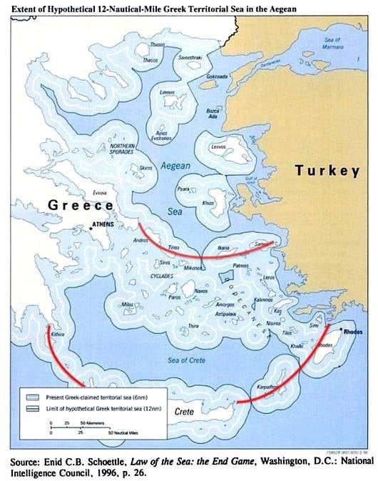 |
| Map of Greek Territorial Waters Zone with 6 and 12 nm: Red arcs have been added to the “straights”. Source: ethnos.gr |
The abovementioned revelations were confirmed by a statement of Prime Minister, Kyriakos Mitsotakis, who “discovered” in 2023 the existence of “NATO islands” (1, 2), and indirectly implied the looming concession of sovereignty (“Lebensraum”) in the Aegean. This clearly undermines the Treaty of Lausanne that Tayyip Erdoğan forcefully puts in the public debate by instrumentalizing the revisionist/maximalist doctrine of the “Blue Homeland” - whose foundations were laid since the 70s -, together with some “willing” Greeks (1, 2, 3, 4) and the well-known fifth column that promotes the dubious so-called “Greek-Turkish friendship” (1, 2, 3). In fact, many characterize the pending Greek-Turkish agreement as the “Prespes of the Aegean – Southern Mediterranean”, for which most of the political system bears responsibility, especially those who governed the country in the post-Junta period.
In hindsight, all these revelations cast light on the deeper reason upon which Turkey sought and achieved the dual name for the Dardanelles Straits (1, 2, 3, 4) on NATO maps -now also referred to as “Turkish Straits”-. Renaming the Dardanelles as “Turkish Straits” - appart from undermining the Treaty of Montreux and the Lausanne - it secures turkish sovereignty of the Straits perpetyally, even if/when the plan to create a “neutral zone” in the Aegean is implemented with the consequent redrawing of borders. At the same time, Turkey - with US blessings - succeeded in undermining the internationally recognized Republic of Cyprus, as its name, areas of jurisdiction and exercises therein, will be described on NATO maps only with coordinates, which foreshadows border changes there as well.
The Eastern Mediterranean
After sketching the picture of the undergoing transformation of the Aegean status quo, we will examine the Eastern Mediterranean, in light of the notorious so-called “Biden’s map” that was leaked in 2019. Thiw map:
-abolishes the “Seville map” which is based on the UNCLOS III provisions,
-takes into consideration claims dictated by Turkey to the US, and
-is currently at an advanced stage of implementation.
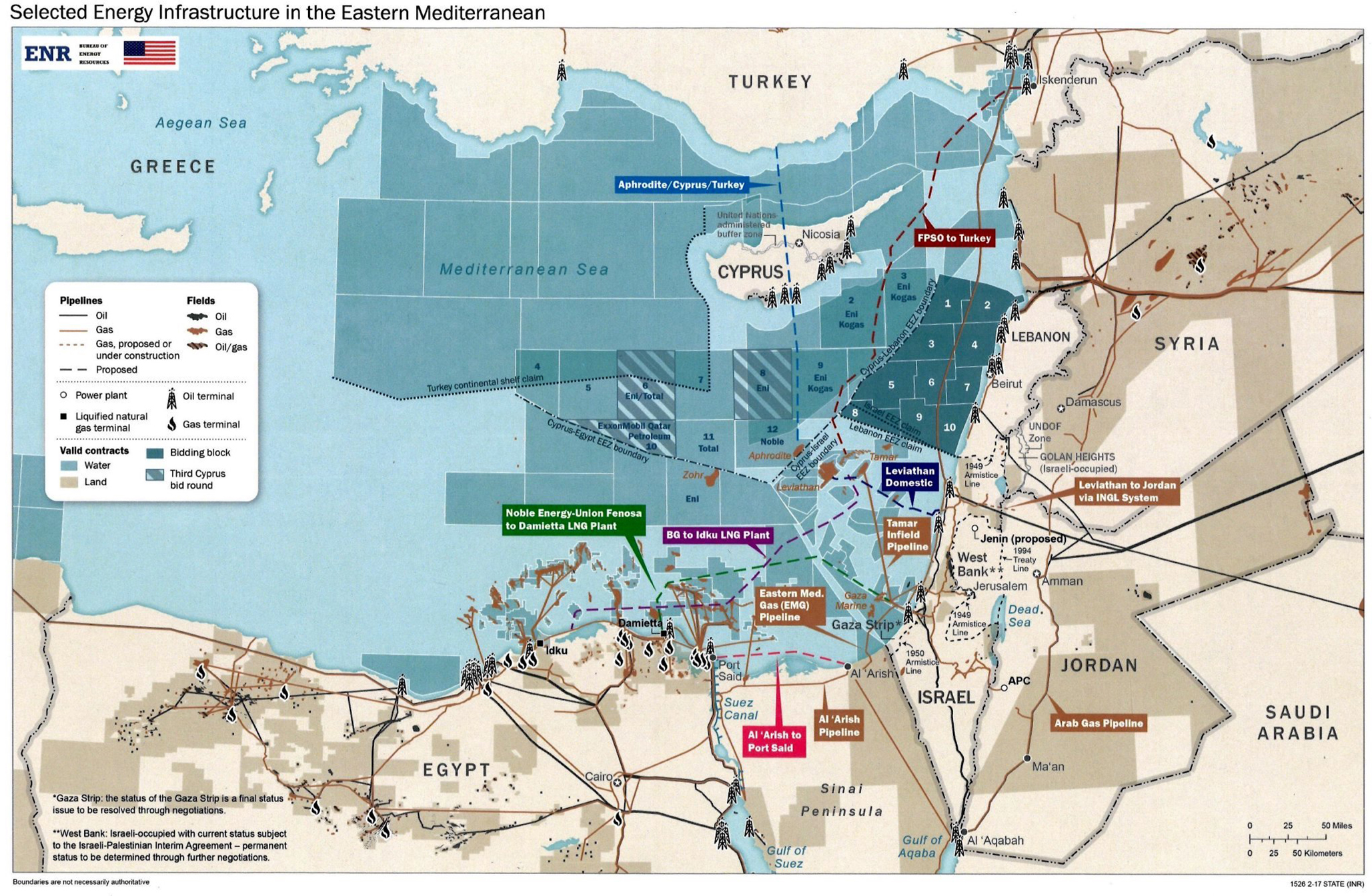 |
| The “Biden map”. Source: mcclatchydc.com |
In a previous analysis (15/10/22) we wrote: “The “prophetical” Biden map (located and republished in Cyprus by Marios Poulados “Simerini of Cyprus”, 11/06/19), was constructed by state cartographers and the energy diplomacy experts of State Department’s, Bureau of Energy Resources, under the instructions/supervision of then Vice President Joe Biden. The map, among many other paradoxes it depicts the following:
-Describes in detail the southeastern limits of the turkish claim for the “turkish continental shelf”, as submitted to the UN one year later (18/05/2020), without incorporating the illegal and unsubstantiated Turkish-Libyan maritime deal provisions.
-It does not depict the EastMed pipeline (see iEpikaira’s detailed analysis), instead it envisages natural gas pipelines running through Turkey leaning towards turkish requests.
-It eliminates the influence of Kastelorizo complex in maritime delimitation, endowing to Turkey the EEZ east of the 28th Meridian [an area in which turkish Research/Survey Vessel, Oruc Reis, carried out illegal surveys for 4.5 months and was not included in the Greek-Egyptian EEZ delimitation agreement. It is noted that Turkey had granted illegal research licenses to TPAO since the 70s in the area in question]…
–It depicts signs of annexation of the occupied northern Cyprus by Turkey.”
 |
| Comparison of Biden’s map (original memo deleted for clarity) with the illegal turkish Navtex surveys of Oruc Reis and the Greek-Egyptian EEZ (A,B,C,D,E) segmental demarcation. Near point A the 28th Meridian. |
The Unified Defense Area Doctrine
It is pointed out that the Doctrine of the “Unified Defense Area” (DUSD) -between Greece and the Republic of Cyprus- opposes the provisions of Biden’s map and is therefore “red flagged”. The DUSD was abandoned after US urging and pressure induced by the Turks, as you will see in the following top secret Greek Ministry of Foreign Affairs telegram (September 18, 2001) that was intercepted and published in Dimitris Milakas' book: “The Secret History of the Aegean” (2012, topontiki.gr). The American intervention therein clearly sets diplomatic obstacles in the preeminent military exercise code name “Nikiphoros” that was inspired in order to settle the DUSD.
“A7 DIRECTORATE
Subject: Exercise Nikiforos
During today’s visit by the American Chargé d’Affaires to Deputy Minister, Mr. Cleverly reported that instructions had been given to raise to the highest possible level in Athens, Nicosia, and Ankara the American concern for the possibility of an accidental and unintended accident during the coming “Nikiforos” military exercise. Mr. Cleverly mentioned that in the past an effort had been made to build confidence measures between Greece and Turkey to avoid unpleasant consequences. Under the current circumstances, he added, when everyone’s attention is focused on the concerted effort to suppress terrorism and cohesion is required, any mishap will create unpleasant consequences. Mr. Cleverly provided yet another potentially unfavorable dimension. He said that in the event of an unavoidable accident, Denktash would take advantage of the event to further hinder the efforts of the UN.
The present Political Adviser, Mr. Kiesling, clarified that the US does not propose to cancel the exercise, but urges for the demonstration of “moderation” and that the Turks are willing to respond “in a restrained and reciprocated manner”, a statement proving that informing of the Turks preceded.”
By gradually abandoning the DUSD, Kostas' Simitis government undermined the security of Kastellorizo as a link between Greek and Cypriot maritime space, allowing Turkey in 2012 to make specific claims in the area, which were taken into consideration by the State Department and were depicted on Biden’s map (2015-2017).
Simultaneously with the abandoning of the DUSD, NATO erased from its maps the maritime borders between Greece and Turkey, as clearly mentioned in another intercepted (topontiki.gr, 31/08/23) top secret Greek Ministry of Foreign Affairs telegram (December 2001). This confirms the implicit intention to re-draw them at a later time:
“DIRECTORATE of Aeronautical Department
As GEETHA (Greek Pentagon) informed us, our country, after signing a relevant agreement in 1996, with the US Geographical Service (National Imagery and Mapping Agency/NIMA/USA) participates in the 1:250,000 scale digital / vector map training program (VMAP). Turkey also participates in this program.
These maps have been agreed to depict the elements contained in the current NATO analog (paper) maps, many of which have been drawn up in 1973 by NIMA. Five (5) of the maps in question (two editions in 1973 and the third edition in 1983) depict the greek and turkish territory and depict the line of the maritime borders between Greece and Turkey.
During the meeting of the VMAP Steering Committee, in May 2001, the US proposed to the Greek side not to display the Greece-Turkey maritime borders on the digital map that was going to prepare. It also stated that was oriented to the revision of the common maps, so that the maritime borders in question are not depicted, following a relevant instruction from the State Department.
After the reaction of the Greek side (in accordance with instructions from the Ministry of Foreign Affairs), NIMA proceeded, in June 2001, unilaterally and without following NATO's procedures for Geographical Policy (i.e. without prior information from NATO, nor prior cooperation with the countries whose territory is depicted), it produced a revision of four analog (paper) maps of Joint Operations Graphic-Air/JOG-A, where the maritime borders of Greece – Turkey -as they are depicted on the maps of 1973- were erased.
According to the argument of the American side, the revision of these maps was done at the behest of the State Department, which is allegedly unaware of the existence of conditions defining the maritime borders of Greece and Turkey acceptable to both countries. Moreover, as an impartial third party, it does not wish to take sides on the conflicting views of Greece and Turkey in this matter. Finally, the aforementioned revision is based on the decision of US to not depict maritime borders on any maps of this type.
According to our information provided by GEETHA, the procedure followed in order to use maps within NATO, is NIMA officially circulating them to the Organization’s countries. At the same time, the USA includes them in its annual publication, the “Geostar A”, which they send to all NATO authorities. Once the maps are released and published as above, possible objections of any allie can be presented at the NATO Geographic Conference, which meets once a year (June), and all member countries participate, while decisions are made with unanimity. Therefore, our subsequent protest at the NATO Geographical Conference will not only be fruitless (due to the unanimity principle), but will also be an opportunity for Turkey to raise the issue of “Greek-Turkish border disputes”, within the framework of a NATO body. Most likely, the issue will be referred for resolution at a bilateral level, between Greece and Turkey.
Based on the above, it is evident that the drawing of the maps in question within NATO will seriously harm our national interests, it will instigate an issue of “border disputes” between Greece and Turkey and will create a precedent for similar actions in the future.”
Summarizing, following State Department’s instructions, the US Geographical Service (National Imagery and Mapping Agency/NIMA) erased the Greek-Turkish maritime borders in 2001. Was this a message to the Turks? Let us investigate this further, going back in time, so that the whole picture of the US plan can be drawn. On 10/15/22 iEpikaira published an article under the headline: “Biden’s map is the evolution of ‘Acheson’s plan’ and its in final stages of implementation!”, from which we copy an excerpt:
Acheson’s Trap
“In a book entitled “Exclusive Economic Zone” (2019) written by Professor Theodoros Karyotis it is pointed out that the biggest problem facing Hellenism is the US policy regarding co-exploitation/co-management of hydrocarbons in the Eastern Mediterranean. US is constantly trying to find the appropriate formula to cede a part of this area to Turkey. This is exactly what the intervention [of former US Secretary of State, Dean Acheson, was aiming for back in 1964. It is clarified that “Acheson’s Plan” -although it is commonly known as that-, was in fact a series of exploratory proposals, under the supervision of the Foreign Office]. According to Professor Karyotis, Acheson’s proposal was very carefully thought through. The Americans knew that Kastellorizo was a key problem but also a “golden fleece”. [Thus Acheson’s proposal included a long-term lease of the Kastellorizo complex by the Turks. The Americans] from an early stage realised that without Kastellorizo, Turkey is completely cut off from the Southern Mediterranean and the rich deposits of the area which they had since then estimated and methodized their division between Greece and Turkey (1, 2, 3, 4, 5). Fifty years on from Acheson proposal, US diplomacy returned to their goal and produced “Biden’s map”. […]
Biden’s map similarities with Acheson’s proposal
– Biden’s map assigns to Turkey the Greek sovereign rights east of the 28th Meridian, possible even the Megistis complex itself, as in the suggestion put forward by Acheson.
– Biden’s map has indications of annexation by Turkey of the occupied Northern Cyprus which are more prominent at Karpasia, as Acheson’s proposal also put forward (on a smaller scale thought, since Acheson’s proposal was put forward 10 years before turkish invasion of 1974). It is also no coincidence that Turkey now insists on the two-state solution in Cyprus, that may act as an intermediate step before annexation. It is clarified that Biden’s map was disclosed to turkish President Recep Tayyip Erdogan between 2015-2017 [-or less likely on late 2014].”
 |
| Indications of annexation of occupied Northren Cyprus on Biden’s map. With red shading is the “potential” EEZ (note: the elimination of territorial waters) of the occupied N. Cyprus. Circled in yellow an imaginary corridor/bridge connecting with the coastline of Turkey. Source: slpress.gr |
Timeline of undermining Greek sovereign rights
Seven years before Acheson’s proposal, in 1957, Hastings Ismay, the first NATO Secretary General, exempted Leros island from NATO Defence Plans, yielding to turkish demands. Then came, Dean Acheson’s 1964 plans, paving the way for turkish invasion of 1974 as well as the illegal research permits in the greek continental shelf, which started in 1973 running up until the end of 2012 (note that the 2012 permits depict a west border on the 28th Meridian, as does Biden’s map).
 |
| Map of turkish TPAO illegal permits from 1973 to the end of 2012. The 2012 permits have a west limit at the 28th Meridian, as does Biden’s map. Source Greek Ministry of Foreign Affairs: mfa.gr |
In 1980, NATO Secretary General, Joseph Luns issued new the policy directives for Aegean islands entitled: “Infrastructure as related to treaty arrangements”, which imposed the exclusion of Lemnos island from NATO’s defence projects. The next step was the elimination of the Greek-Turkish maritime borders from NATO maps in 2001. In 2006, the SACEUR, General James Jones, exempted all the “demilitarized” islands – according to the turkish narrative – from NATO military exercises.
 |
| Joseph Luns NATO directives. Source: Fanoula Argyrou’s personnal archives. Credit to NATO Archives’ personnel for their helpful response and assistance. |
After the intention was cemented, the new theoretical maritime borders were then marked on Biden’s map (2015 – 2017), solemnly graying out greek maritime jurisdiction in the Southern Mediterranean. An area that in 2020 turkish Research/Survey Vessel, Oruc Reis “plowed”, achieving a feat on the field that will be difficult to undo, with the Greek Armed Forces having been instructed to monitor discreetly the procedure from a distance.
It is recalled that the illegal seismic surveys of Oruc Reis were carried out in a specific area that essentially cuts off the maritime boundary between Greece and the Republic of Cyprus and also blocks the route of EastMed (the pipeline to which the US dropped its support by issuing a non-paper which – for the record – was leaked in January 2022 but it is speculated to have been distributed in October-November 2021 and had a “strong turkish flavor” [1, 2, 3]).
State Department’s announcement regarding the illegal turkish surveys for the first time described the specific area as “disputed waters”, which came to complement the preceding remark of the former British Minister for Europe, Sir Alan Duncan (14/05/19), about “sovereignty under dispute”, when asked in the House of Commons about Turkey’s decision to illegally drill in the Republic of Cyprus’ EEZ.
The overall redrawing of the maritime borders will inevitably affect the airspace as well – without going into details here –, as iEpikaira already explained (20/03/24). The addition of “Skies” to the “Blue Homeland” doctrine by turkish Minister of National Defence, Yaşar GÜLER, means that the maritime borders aimed to coincide with the FIR.
The reason behind border redrawal attempts
For those who may look for a reason behind redrawing the borders in the Aegean and the Southern Mediterranean, the answer can be found in the announcement of the connecting route between Europe and the Indian Ocean, through the Southern Mediterranean and the Aegean, otherwise known as India-Middle East-Europe Economic Corridor (IMEC).
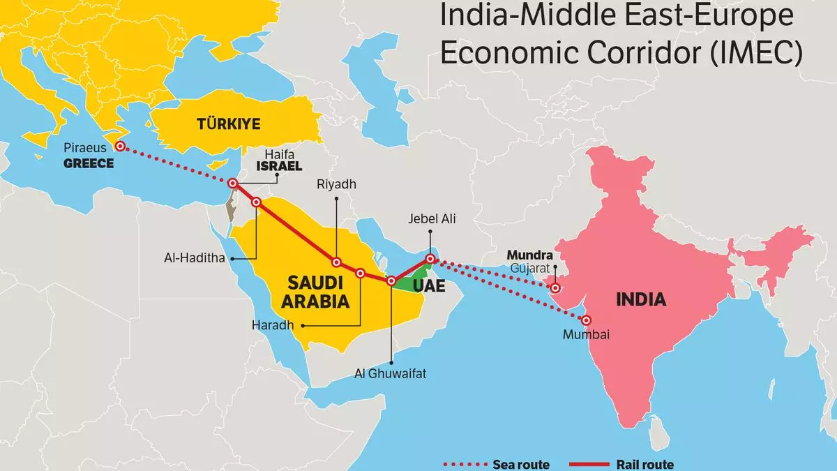 |
| IMEC: India – Middle East – Europe Economic Corridor |
Although the announcement of implementing IMEC refers to the port of Piraeus as the gateway to the EU, it is possible that the port of Thessaloniki or Alexandroupolis may be chosen instead. After all, it is not a secret that some consider these wider areas prime candidates for Special Economic Zones (SEZ) (1, 2, 3, 4), which on one hand would allow easier control of the economic corridor by third parties and on the other hand would connect IMEC with the NATO-inspired “Three Seas Initiative” which reaches the Baltic Sea -now turned into a “NATO lake”-. All these constitute individual parts of the overall “Grand Strategy of USA” – not analyzed here – which is implemented gradually, with Greece and Cyprus being in the “eye” of the global “geopolitical cyclone”.
 |
| Three Seas Initiative with 12 EU Member States in Central and Eastern Europe between the Baltic Sea, the Black Sea and the Adriatic Sea. With Greece's participation, access to the Aegean Sea is gained as well. |
Findings
Panagiotis Kondylis, one of the greatest thinkers and theorists of war, in his iconic work “Theory of War” (1997), makes the grim observation that Hellenism has been shrinking continuously over the last century. He writes: “this is an extremely dense chain of national catastrophes within a period that is small from a historical point of view”, and explains:
“The nation finally coincided with the states' borders, not because the state expanded, but because the nation was mutilated and shrunk, because the Hellenism of Russia (after 1919), of Asia Minor (after 1922), of the Balkans and the Middle East (especially after 1945) disappeared or was displaced. This was followed by the expulsion of Hellenism from Constantinople (1955) and turkish invasion to Northern Cyprus (1974).”
He added that “the proven inability of the Greek state to defend the Greek nation – that is, to fulfill its mission par excellence – is the most ominous sign for the future”, while he concluded that “Greece is steadily turning into a country with undermined sovereign rights, i.e. rights whose sovereign exercise depends on the will and reactions of third parties, while at the same time its attitude is becoming more and more passive or contradictory.”
“Under these circumstances” he argued “what will in fact constitute a bending of the Greek resistance under the pressure of the superior turkish geopolitical potential, the Greeks will slowly get used to calling it “civilized behavior”, “transcendence of nationalism” and “Europeanization”.” “Consensuality” some others call it in Athens, adopting the favorite terminology of specific Turko-friendly circles (1, 2, 3).
The insightful thinking of Neoklis Sarris is now fulfilled. Some years back he argued that “in a few years the Turks will make the Greeks think like Turks and this will be our biggest defeat”. The patriotic feelings of Greek people are suppressed by the anti-patriotic McCarthyism of a large portion of the political staff, otherwise known as “geopolitical sleepwalkers” of a party system that plagues the country.
Can anyone disagree? Hellenism as a whole (Greece and Cyprus, in which the “hostage of hundreds of thousands of Greeks” constitutes an “unbearable strategic entrapment of Greece” according to Professor Panagiotis Ifaistos) is rapidly heading towards the biggest crisis since the “Asia Minor Catastrophe”. The coming months will determine its course and the future of generations to come.
Source: i-epikaira.blogspot.com based on a rendintion by helleniscope.com
.png)